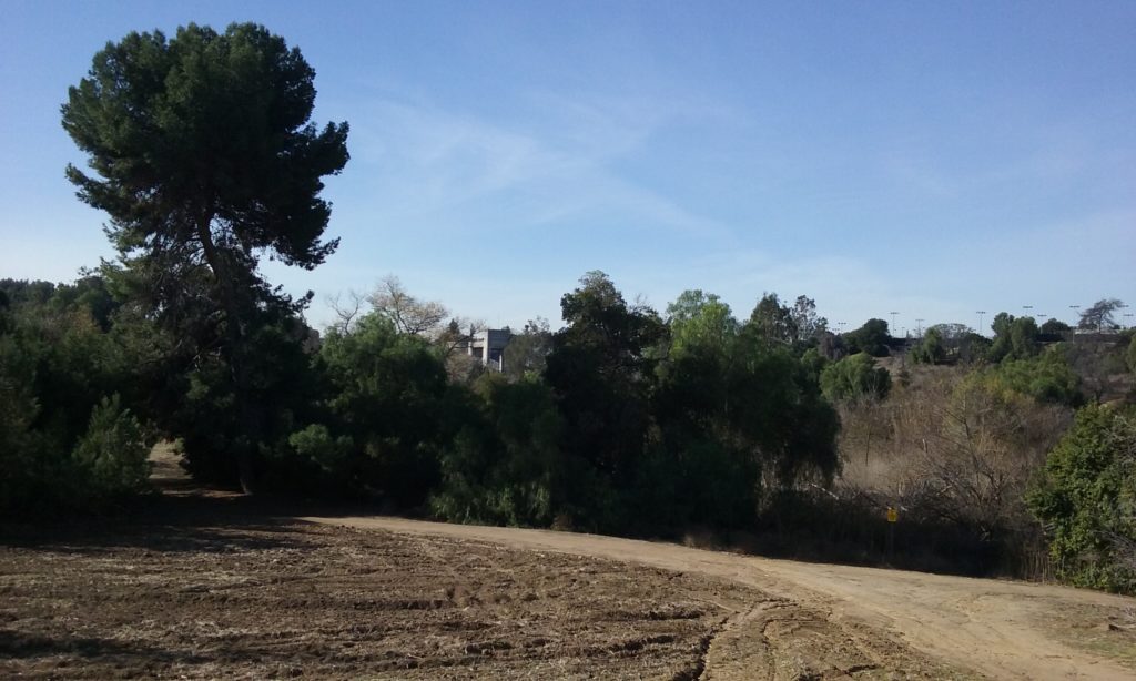
(To go directly to the description of the “walks” hit the page down key 3 times.) This sight of 220 acres of no houses has never been seen by most who live in the very city this is in the middle of. There’s only a 3 second view of it for those that drive just east of St. Jude on Bastanchury. There used to be the back four holes of the Fullerton Golf Course but it is now only used by hikers and bikers as they whiz through a trail to the east side of the 8 story high dam that also few people have ever seen. As a golf course more of this vast acreage was used than by trail users. The cause of its demise was the weather and of course the original purpose of this area. It is a flood basin after all.
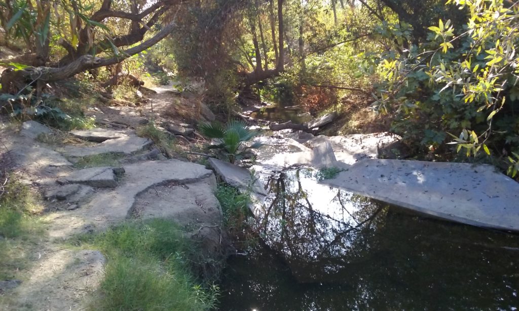
___The damage caused by one particularly bad storm (1983) is most visible on the south side of the two parallel tunnels under Bastanchury. (Pictures of the wreckage, below.) The repair costs to the city for the greens after that storm was just too much, so the entire Brea Creek Reservoir (flood basin between Bastanchury and the dam) is now wilderness for hiking and biking. (Hooray for us.) That’s about 220 acres the Army Corps of Engineers leases to Fullerton for a dollar a year. Click here to see the official agreement. This is one of two dams in Fullerton. The other dam –just a two miles away– is called Fullerton Dam because its creek is Fullerton Creek. The bigger dam (by far) is this one named after Brea Creek. The flood control basin for Fullerton Dam is Craig Park; a county park. For more about the history and technology of dams click on Dams and Spillways of Fullerton. For more on Craig Park <–click there.
Accessing the 220 Acre Brea Reservoir (Brea Creek Flood basin)
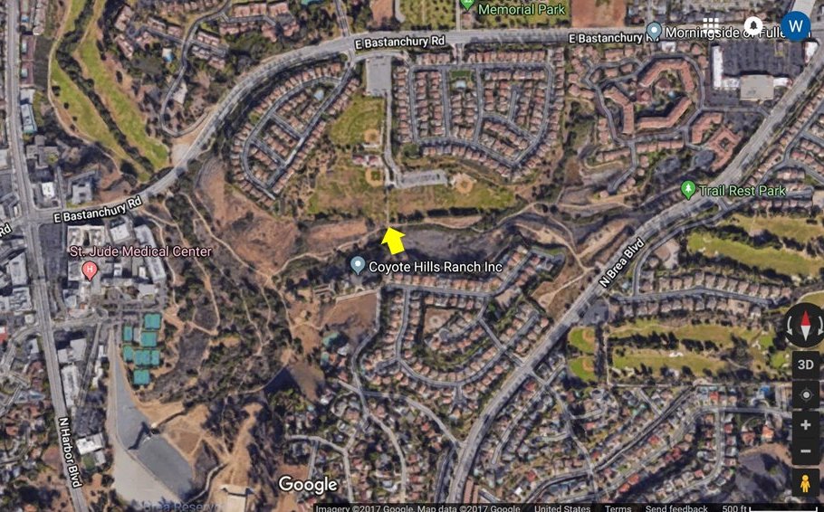
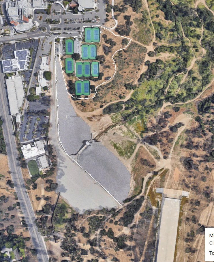
There’s only one really good spot to park to explore this area. This 220 acres is absolutely hidden from view from any road, yet right in the middle of Fullerton. Your first site of the dam and recreation area should be quite a thrill. So in a way it is wonderful that there is only one convenient place to enter. (Even from that parking place you have walk quite a ways to see this stunning view.) This one good spot to park is the Fullerton’s Sports Complex. Going east on Bastanchury from Harbor, it’s the first right after the interesting dip and S turns Bastanchury makes. There’s two parking lots. Drive on to the back one where you will see a concrete sidewalk which eventually meets a dirt trail that goes roughly east-west. That point is the yellow reference arrow in this satellite view to the left above.
____In this entire 220 acre flood control basin there’s not one single trashcan. (This is not a park; remember.) The Sports Complex has them all over the place, but the only one in the entire 220 acres is one at the end of the Sports Complex sidewalk that leads to the Lost Trail. It is up to us to take out any trash we bring in. And in fact, pleasure can be taken at taking out any trash we see in the flood basin. For more on the reward and exercise of making the world more scenic, <– click there.
Walks
East of that Sports Complex Reference Point (out and back .9 mi)
The walk to the left takes you to Brea Blvd which on the map is called Trail Rest Park. That trail is named Lost Trail and was created by a young Dennis Quinlivan in the 70s. He is now superintendent of Landscaping Department. The east end of the trail is undeveloped with no place around there to park; hence the name Trail Rest, not Trail Start or Trail End. If this spot would be developed it would probably be just a bench and a sign to signify a junction of three trails; two of which are on the other side of Brea Blvd. Those two trails are described in the webpage –> East Coyote Hills Trail.
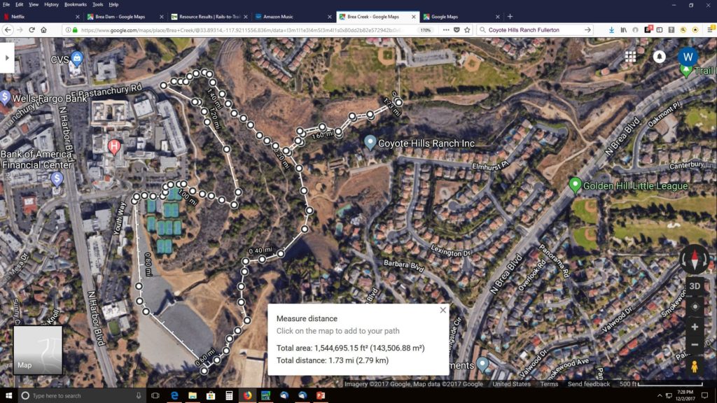
In the area between Trail Rest Park and the Sports Complex are a number of trails created by bikers. It’s good to remember that any trail you see ends up somewhere. Do not be afraid to walk a trail that seems to go off into infinity. A trail is maintained by use and it won’t be used unless there is a destination. (Kind of first rule of trials.) The main one going east from the Sports Complex gets to Trail Rest Park. But the more numerous small trials that go south and east ends up on a Chevron Oil Field. (Now Breitburn Energy). There are many ambiguities about trails and railroad tracks and oil fields. They can’t very well encourage you to trespass but it is far too costly to fence it off. Do not be afraid of walking anywhere. You can find your way to be close to several oil wells. They are themselves fenced in, so you are quite safe. From that oilfield on the far south east you walk right onto the Brea Blvd sidewalk without climbing any fence. You will be amazed at the huge amount of real estate for just one oil well. (There are no signs or evidence that want to keep walkers away.) Once on the sidewalk you can walk to Trail Rest Park making kind of a loop. From the Sports Complex to Trail Rest Park and back is .9 miles. Or if you add on the loop through the mini-oilfield in the southeast corner then along the sidewalk to Trail Rest, it’s 1.2 miles.
West out of that Sports Complex (out and back .8 miles)
Going west from the Sports Complex you will encounter dozens of bike trails of various widths depending on how well traveled they are. Even the main trails are two numerous and winding to describe. The important thing to note is you can’t get lost. You are in a basin and you can see where you are going by noting the land marks on the raised horizon. Saint Jude Hospital is to the west; the dam is south and the cell phone towers marks where the Fullerton Tennis Courts are. The tunnels under Bastanchury are at your level so you can’t see them, but you can see the Hospital and picture where Bastanchury is that goes over those tunnels.
You can go through the tunnels to the golf course where there’s another trail described in the webpage –> San Juan Park. The two tunnels are the best way to get to the other side of the Brea creek. Go out one and back in the other. The tunnels are probably the most interesting goal. Out and back to them (from the Sports Complex) is .8 mile.
The Less Interesting West Side of Brea Creek (out and back 1.4 and 1.7 miles)
It is good to note that the Brea Creek down the middle of the 220 acres can only be crossed over the crest of the dam or by way of the tunnels under Bastanchury. That makes the area on either side of the creek as separate as if they were in different cities. The east side main trail (the Sports Complex side) leads to many more trails on the way to the dam, than the main trail on the west side. Crossing in front of the dam is out of the question even in the summer. Crossing from one side to the other is only done by walking the crest of the dam. (It’s a lot of work. You can find your way from the basin to either side of the dam to get to the crest and then over to the other side.)
_____The tunnels under Bastanchury on the north end of the basin is the only other way to cross over. Starting from the tunnels, the less interesting side, the west side, goes past the parking structure of Saint Jude. It ends at two trails that lead up to the eleven Fullerton Parks and Recreation Tennis Courts. The easiest way out of the park from the west side of the basin is easy to spot because it is at the base of the cellphone towers which can be seen from anywhere. Starting from the Sports complex, out one tunnel and in the other and then to the Fullerton Tennis Courts is 1.4 miles. If you walk beyond the tennis courts across the crest of the dam, to the east end of the dam and then back along the east side of Brea Creek is a 1.7 mile loop.
End-of-Asphalt Reference Point
If the Brea Dam Recreational Area will be developed, chances are the End-of-Asphalt Reference Point will be important. And the best place to park for that reference point is the formal entrance on Harbor to Brea Dam Park (a block or so north of Brea Blvd). On foot, find your way to the north east side of the picnic area. There you will find a trail that goes directly to the east side of the dam crest. (There’s an access road to the south that also gets there, but is only open when the hostel is in operation; a few months in the summer.)
Walking north from the crest on the asphalt downhill you will come to the end of the asphalt. The end of the asphalt is a very good reference for four different adventures (described in the next paragraph) To see this reference point from a satellite’s point of view click here–> End of Asphalt Reference. You can see that very map more interactively by using Google Earth yourself. Just enter this 33°53’26.3″N 117°55’26.9″W into Google and click on Maps (Click here–> to learn how to use Google Maps in 3D.) You can of course find your way to this important reference point from the Sports Complex parking lot. Its about a half a mile as opposed to a quarter of a mile from the Harbor entrance.

- Looking north there’s a stand of tall trees on the left and in the back a deposit of dirt left over from making this large flat area. Do not miss a view of the basin from that deposit of dirt at the north end of this flat area.
- Looking west from this references point, there’s a huge concrete tie-down for the chain of logs that prevent floating debris from entering the dam’s penstocks during a storm.
- Looking north-west there’s a wide trail that goes down into the basin. This trail has many branches out away from it. You will find them fun to explore and keep in mind this: You can’t get lost in a basin because your horizon with landmarks is above you and always in sight.
- Looking south-east is the spillway. Notice the hills that rise up on either side of the spillway. The trails around these hills are described in the webpage–> Brea Dam Park (east of the dam)
Trails Under the Tennis Courts
From any map, one would think that there is an entrance to the 220 acres by way of the Fullerton Tennis Court. But unless you are member and willing to pay for parking, you should not consider this an entrance. Instead start from the “end-of-asphalt-reference-point” described above, and walk the crest of the dam toward the hospital. Where the dam crest joins the city you can explore the facilities up there next to St. Jude. There’s the tennis courts, the YMCA and a trail down into the basin. (The YMCA has two large snack machines with health food as contents. And a water fountain of course.) ____
 There is something of a secret abandoned trail located just below the tennis courts. (picture to the left) It is easy to get at from the trail that goes down from the cell phone tower; about a hundred yards. It goes to the right and for some reason gets less and less used until about a hundred yards in where it vanishes. Continue on until you find a very round clearing with an amazing view of the flood basin looking east. This is an unusual direction for a scenic view of the basin. Further on you will find an abandoned pavement sidewalk and then an interesting view of the dam itself. (Taking pictures is tough because the shrubs are never cut back.) Continuing on the trail disappears entirely but you can find your way to the dirt road which the Army Corps of Engineers uses to access to the inlet of the dam. Walk up hill to get back to the sidewalk next to the tennis courts entrance.

Short Walk to a Most Interesting Destination; a Horse Ranch (10 minute walk) Coyote Hills Horse Ranch is a privately own stable for boarding horses. They are proud to brag that from their stables, there some 28 miles of trails are accessible by horse including all the way to the riding arena at Laguna Lake at Euclid. Of course those are the trials that this website is all about. All of the trails are now maintained by Fullerton Parks but were originally developed and maintained by the Fullerton Recreational Riders in the early 1960s. The names of the various trails Nora Kuttner, for example, were important members of that club. Alas, they don’t offer horseback riding for the public from Coyote Hills Horse Ranch any more, but there is something worth going there to see on Saturday Mornings; 11:00 AM. Its called Therapeutic Riding. It’s for children with disabilities. There’s some small bleachers where you can observe. Click here for more on Coyote Hills Horse Ranch and Taras Chance. If this horse ranch is your destination, starting at the Sports Complex is way to close. It’s only a five minute walk from there. There is a pretty good walk starting from the other side of Bastanchury to the ranch. For details on that walk see–> San Juan Park Trail.
Click on the pictures to see them as full screen.
Questions for Anyone
What was reason the concrete was so buckled and what did it look like before?
Suggestions for Parks Department
In Craig Park there’s a low maintenance trail called Cottonwood. It is low maintenance in that hikers can wander around in there making their own trails. The idea is to expose the public to native plants that grow next to standing water. I think there’s potential for a much better version, a longer version anyway, just south of the Bastanchury tunnels. It has an excellent start just by folks exploring around in there. A good project for boy scouts maybe is to extend or better yet find other places along the creek which can be entered from the side.
