
Purpose of a Flood Control Dam Both the Fullerton Dam and Brea Dam are in the category of flood control. Flood control dams do that by making the flow out of the dam to be the average amount of water flow instead of the peak flow. In engineering language it is like a filter capacitor where the reservoir behind the dam is the capacitor and the penstock is the resistance. Penstocks are gate valves which are raised with electric motors during any rain. (Not just during a storm) The gate buffers the normal changes in the flow of the creeks so that downstream of a dam, the flow is never more than the channels can handle. That means water will be flowing out of the dam for many hours after the rain. This regulation allows the water to be conducted through the city in channels so narrow as to almost disappear on an areal photo.

Upstream of a dam, the creek is at the bottom of a ravine that appears so much bigger than the creek. That’s because the flow is quite varied there; it could require the whole ravine or barely a trickle down in the weed strewn center. The dam’s regulation of that varied flow is tricky because as the height of the water against the face of the dam gets higher, the higher pressure would force more water out of even a small opening. As the water level goes up, the penstock valves have to close a little more to be the same outflow. Inside the dam, the motors that run the penstocks to modulate that flow could be automated, but in a catastrophic storm the dam is protecting a whole city below it, so there is a tradition (and law perhaps) of having human operators; one for each dam. And since they have to be there in a potential flood condition, they might as well have manual operation for normal rain conditions as well. It keeps them intimately familiar with the controls and aware of any malfunction in conditions that are not severe.
Dirt Dams  Most dams in the world are like the two in Fullerton: flood control, made of dirt with a protective coating of rocks. The dirt is gathered from upstream side, but never to make the creek bed deeper. (The intake of the dam has to be the lowest spot.) It is to make the basin wider and flatter, to hold more water of course. This also makes the area available for alternate uses such as a playground for hikers or even golf courses; uses that can tolerate the occasional flooding. The dirt that is piled up to form the dam is not as compacted or as wide as the hills around the basin so it has to be protected from rain erosion and of course leaks when the basin is full for a long time. The problem of leaks through the dam is reduced with the building of a vertical wall of silt inside the dirt pile which is impermeable to water. Yes, the rest of the dam is like the dirt under the dam –a sponge– dirt with the ability to flow water the same way a well is replenished. Without a silt wall, the flow emerges as a leak somewhere on the down stream side. It’s like a spring, but a spring on the side of a slope that could erode in time. That increases the flow which makes for faster erosion and so on until it undermines the dam. This extra measure of a silt wall is not necessary when the dam can be emptied in a matter of a few weeks. (Our dams don’t have such a wall of silt.)
 The most visible part of a dirt dam is the rock covering. One of the most underappreciated facts of dam building, of geology and of the environment is the deliberate use of rocks. Rocks disrupt the flow of rain water so that ruts can’t form. Rock is not there to protect it, if water goes over the dam. Nothing protects a dam from that. The mechanism for preventing rocks is hard to describe but very evident when you see portions of a trail that are strewn with rocks next to portions that are bare dirt. The bare dirt has ruts the get deeper with every rain. There’s a much more important role that rocks play. They shade the soil from the sun. The fact that you can’t see dirt on the face of the Fullerton dams means that the dirt can’t see the sun either. That means seeds can get started growing in the dirt under the rocks. It’s like permanent weed killer. Mosquito abatement uses the same trick. That’s why rangers have their crews put large rocks to be piled up in parts of a stream that tend to have still water. Mosquitoes won’t lay their eggs in water that is shaded.

There are other categories of dams. The small dam at the downstream side of Craig Park lake is an example of a weir dam, or weir gate where the water flows over the dam instead of under it. They are the smallest kind of dam and are used to keep the level of a small lake upstream of the dam constant; without varying an inch. It does this by allowing excess water to go over a very wide and flat crest. And this kind of dam works without controls. Note the difference. The flood control dam (described above) controls the flow downstream; the weir dam controls the level of water upstream. (As you might guess, you can’t do both with the same dam.) The economic difference is one needs an operator; the other does not. Note also, that when water flows over the dam, the flow area must be made of concrete. If the water goes under the dam, only the channel needs to be lined with concrete. The bulk of the dam itself can be made of dirt.
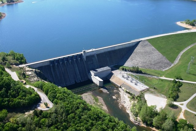 Another category of dam is a big one like the flood control dam but is used to back up a lake for which it is important to be of a constant level. It is like the weir dam but the flow is under the dam instead of over it so that a wide area doesn’t have to be made erosion proof. This requires constant adjustment of the flow under the dam. These large (recreation) dams are usually under automatic control and yet also have a dam tender. (More on their job below.) The dams for a large lake require very expensive hardware that is also able to protect the dam in a catastrophic storm. The flood control dam which also has the control valve underneath (like ours) can get away with much cheaper protection because the lake height is not held constant. The protection in both cases is called a spillway.
The Two Fullerton Spillways

Our Two Spillways are there for the sole purpose of protecting their dams in a catastrophic series of storms. Like most spillways they used a lot of concrete and their cost approaches that of the dam itself. The costs could be even more if the flow beyond the spillway was protected against erosion. It isn’t. There is a point where the flow is over dirt. The trick is to place the spillway so that when erosion happens it won’t undermine the dam or the spillway crest. It just makes a mess that can be cleaned up later. Perhaps the most important point about spillways is that when they go into action (once in the lifetime of the dam) rain has not stopped and the flow they must contain is the same as if the dam wasn’t there at all. There is no more storing of water.
____The kind of spillway used in the two Fullerton flood control dams are passive; no moving parts. Spillways of this type rarely go into action to save a dam. In most cases never once in the history of a dam, which could be more than a 100 years. More important, there’s no way to test how the water is handled. (Other kinds of spillways are frequently used for water level control in addition to being a safety valve.) There is a great hazard that dam tenders have to anticipate and that is that if years of drought has created dead trees in the flood basin that have not been removed, they could clog the spillway endangering the dam.

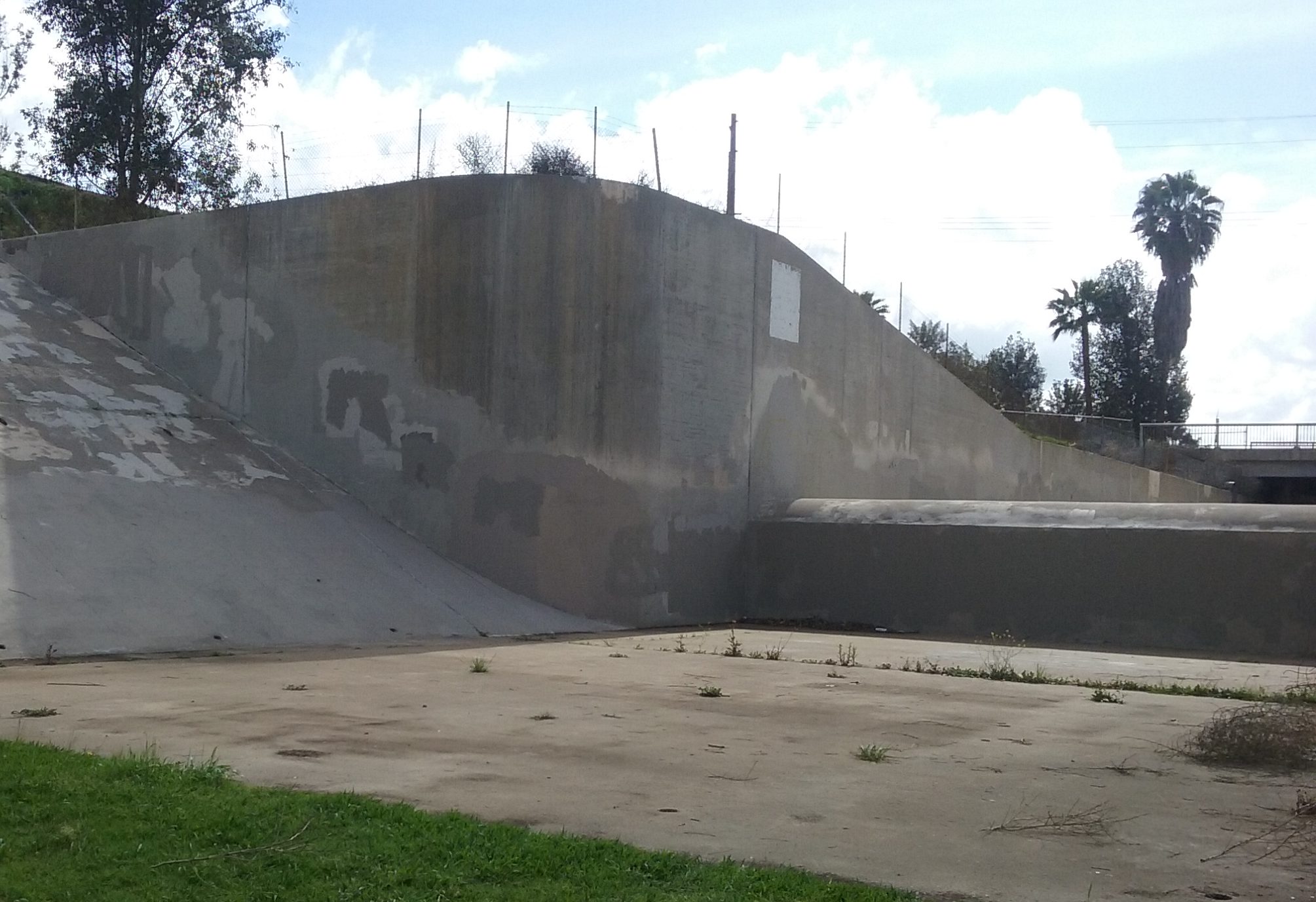
Why are spillways necessary? Dams (to be affordable) are weaker and lower than the hills that line the flood basin. This is because, it is difficult to make the same structure both tall and tough enough to survive erosion if it should be overrun. The two Fullerton dams (most dams) are piled up dirt taken from nearby. This dirt is geologically very soft and easily destroyed in an erosive fault. If lake water was ever to flow over the crest of a dam, even with a rock face, the water will find a place to erode and in just a few hours catastrophically fail, destroying the whole city… damage far worse than having no dam there at all. All dams (even in ancient times) are protected with spillways off to one side. Spillways are safety relief valves that are deliberately chosen to dump excess water far from the dam. But unlike a relief valve for steam, the water going over a spillway is very high and when it comes out there is a large amount of energy to be dissipated by the time it gets to the down-stream stream bed. It was mentioned above that erosion is inevitable where the spillway concrete ends. It is the velocity of the water that is so erosive. If there’s no place far from the dam where erosion is safe the spillway has to be able to slow the water down –use up its energy– before it gets to the dirt. An example of that is shown below in the step spillway. (It is like a giant weir dam.)

When water is going over the crest of the spillway it floods the streets and perhaps dozens of businesses downstream of the spillway. Remember that’s only in the extremely unlikely event of several super storms in a row. (Spillways on large dams that back up lakes have controlled releases that go down a river. Their use is not just for safety of the dam.) ___Do not confuse the once in a hundred years use of a spillway (doing its job to protect the dam) and the far more rare event of a dam failing. When you hear in the news that people are being evacuated it is from areas to be flooded by a spillway in its proper functioning. It is extremely unlikely any dam built in the last century would go. In the news in February 2017 was the evacuation of nearly 200 thousand people down stream of Oroville dam. In that case the spillway was doing its job of saving the dam, and in the process of saving the dam, would be flood enough, but the flow eroded a hole a in the concrete lining of the spillway, a third the way down (This was its first use in 50 years; you can’t test passive spillways.) The concrete wasn’t thick enough. Erosion where the concrete ends is OK but not where the flow is so fast. There was the possibility of the spillway failing close enough to the lake that erosion would be catastrophic. That would have been as tragic as the dam going. The rain stopped and the level of the lake sufficiently lowered (by flow through the spillway), that the flow over the crest of the spillway eventually stopped. Catastrophe happens when the erosion makes the hole deep enough that the lake can drain through it. (Not just the water over the spillway crest.) The spillway saved the dam and the spillway since then was made less fragile.
In Case You Are Worried About Our Spillways.
If the spillway for The Fullerton Dam (south east corner of Craig Park) was to go into action to save the dam, the spillway would empty its flow onto Bastanchury near where it goes under the 57. It would then flood Associated Road, Yorba Linda Blvd and finally State College where it would find its way to the ocean.
If the spillway for The Brea Dam (east of the hill that is Fullerton’s Brea Dam Park) was to go into action The Golfers Paradise Driving Range would be flooded. The water would flow from there into Harbor Blvd. where it will become an excellent river to the sea.
____Those floodings would be merely an inconvenience, compared to lives and buildings lost if the dam would go. Burdens associated with spillways in action also includes mud deposited on the roads from the high speed flow where the concrete ends. The velocity of the flow can be quite high and lift dirt up from a large hole and carry that soil down to the streets. It should be reminded once again, that once the water is at the crest of the spillway and the downpour is continuing, the amount of the flow is the same as if the dam wasn’t there; flow that by itself is enough to flood the city. In the picture below note the height of the concrete sides. That’s how thick the stream of water would be going through the spillway and moving at about 20 miles an hour. (No, it has never come to that here.)
 ___It is interesting to note how the Corp of Engineers calculate the size of the spillway in a storm event that is once in 400 years in a country that wasn’t even settled, let alone having any record of flood that long ago. No, it’s not tree ring data. We have no old trees. Every tree you see in Fullerton now was planted since the city was incorporated. The record for rainfall only goes back in this region about a hundred years. However, that’s enough. When a histogram is plotted of that data for the number of storms (that’s the vertical axis) and the amount of water flowing through the region, (that’s the horizontal axis; heavy rainfall to the right) it forms a distribution that mathematicians can recognize (Gaussian distribution is just one of many). They then can apply formulas to that curve to extrapolate it way beyond the last recorded data point. These extreme positions are called –> black swan events. Black swan events are important because failing to recognize them is so horrible, but overbuilding can be terribly costly.
More Complex Spillways
There is a way to postpone damage done by the spillway by allowing the water level to rise higher on the dam –to the very crest of the dam– before it is allowed to go down the spillway. But that’s tricky. First it should be noted why the spillway goes into action way before the water level gets to the crest of the dam. The spillway ledge has to be several feet lower than the safe height of the dam. When you look at the spillway crest in the picture above, notice that the concrete walls are quite a bit higher. Picture the water flowing over the ledge between those walls. That corresponds to all the rain fall in a terrible storm in that dam’s catchment basin. For Fullerton Dam it is only 3 square miles. Brea Dam is 234 square miles. For that much water it may need to be 3 feet thick going over that ledge. It is that three feet that water will be raised to on the dam face (and everywhere else). But that means that it starts letting water out way before it reaches three feet thick. The streets must take that flow even if the flow is only a few inches thick. And don’t forget the storm drains there have long before been saturated.
 Even More Elaborate Spillways
Most safety valve spillways are passive. If the spillway is of the type that can postpone their use on the chance the rain will subside, they have be very elaborate gates with very reliable gears and motors. A spillway gate with motors can be placed on the spillway crest so that the water can be held back until the water level raises to the crest of the dam, the streets won’t have to take the few inches of flow over the spillway. That extra amount of time to fill the reservoir higher can be many days even; allowing time enough for the storm to pass. The need to raise the gates would then historically be even rarer than a passive spillway ever going into operation. (From a 100 year flood to a 400 year flood.) But when the gates do open the streets are so flooded no traffic could pass and some buildings lost. Historically this trick of postponing the opening was achieved with a wood gate above the spillway crest (called stop-logs) where explosives could be installed just before an anticipated huge storm. That way if the weatherman was wrong, and it continued to rain even after it got to the top of the wood ledge it can be blown up and the flow commenced in earnest. An even more interesting spillway is a “fuse” spillway. The top two or three feet above the ledge is made of dirt piled up. When the flow goes over the top of the dirt, the force of the water erodes the dirt pile in the course of a few minutes and flow is suddenly very large.
____Here’s some video of spillways that are frequently opened. The title says emergency, but that’s only to get your attention. In fact crest gates are opened annually just to exercise the equipment and test the discharge channel for leaks. (Spillway channels that use streets are obviously never tested.) Spectacular Spillways in Operation.
If the dam is miles from a city so the spillway with motor driven gates can be used without flooding streets, it will allow the water to be at the rim of the dam all year round, in which case it is not a flood control dam; it is a lake forming dam. The value of letting the water level be as high as possible means a much larger lake for the same size dam. (Even a single foot of height can mean hundreds of acres larger lake.) As mentioned above our dams are not to hold a lake but to limit the outflow to what the channel through the city can handle. Whatever amount the rainfall, the flow out of our dams have to be carefully controlled. The reason is that the gate is at the bottom. As the water level rises, the pressure increases and so gate opening has to be decreased to have the same flow. Even if that was to be automated, there still has to be a man there to operate the various backup ways to circumvent some malfunction. Dam tenders (operators) are at their station at all of our dams every day before, during and after any rain whatsoever. They are invisible heroes.

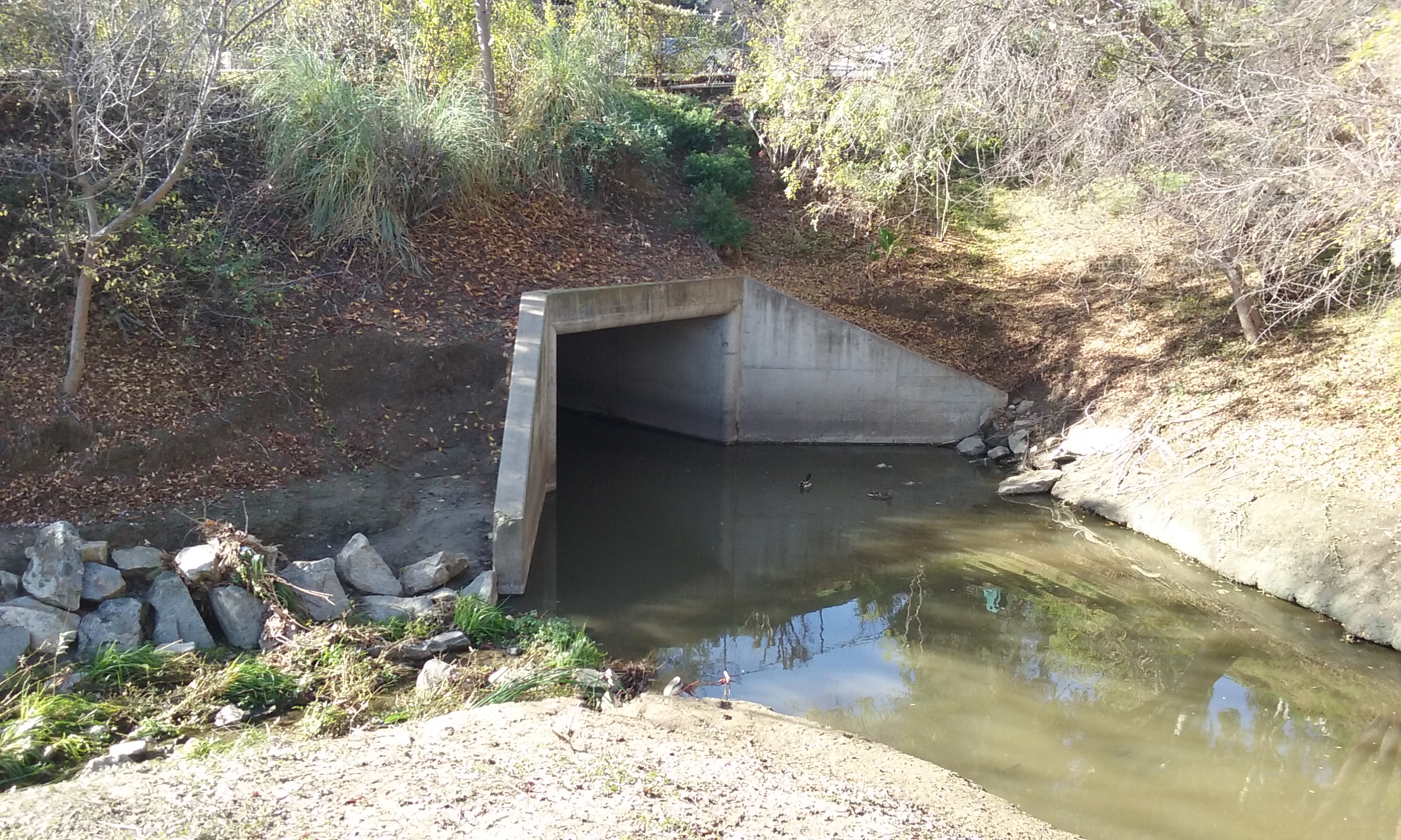
Babbling Brook, Brea Creek Brea Creek is the flow that is on both sides of the Brea Dam (the dam near Harbor Blvd.) Even in the summer there’s a bit of flowing water from the runoff of neighbors watering their yards. The upstream flow is most visible on the south side of the tunnels. The tunnels are a landmark because they go under Bastanchury Blvd. Right there next to the tunnels is the closest one can get to the water. (Very scenic, by the way.) The channel gets deeper and more crowded with plant life further away from the tunnels in either direction.
How to Enjoy the Brook When you visit the creek near the tunnels, the better side to be on is the south end of the east tunnel. Find you way south on the broken concrete until you get to a dirt trail along side the creek. It is not a difficult to follow the trail but you have to duck under branches which makes it look like you aren’t supposed to be there. But for heaven’s sake do not miss this experience. Not only can you see and hear a babbling brook, it very shady too. Such a nice spot is too good to be true and will be made illegal somehow, someday by some do-gooder. Broken concrete is an adventure to some and yet something to remove to others.

History of Damage The tunnels were probably the size they were to accommodate golf carts. Not flow. In fact at the peak of the 1983 flood, there was more water than could go through the tunnels. It went over Bastanchury right there. When the golf course was built, four of the 18 holes were on the south side of the tunnels, almost to the very rock face of the dam. The size of these tunnels handle ordinary storms, but light rain and runoff flows, go through a 36” pipe under the two tunnels. That’s why you can walk through the tunnels without getting your feet wet, most of the time. When those tunnels are handling the flow in addition to the 36″ pipe the golf course is under water. In the picture to the right, it looks like the water was a great destructive force. But this kind of rubble pile looks more like restoration that was stopped for lack of funding. The reason the golf course was abandoned on this side is not the erosion of the flow. It was the cost of replacing the lawn. The upstream end of the golf course being farther from the dam could be drained of water in only a few days. On the south side of the tunnels where holes 7 through 11 were, the water would be deeper and there for many weeks. That would certainly kill the grass and require replacement.
 Babbling Brook of Fullerton Creek; Craig Park
Water flowing out of a dam is kind of boring because the level is so constant. But upstream of a dam is the excitement of varying amounts of water. For Fullerton creek that passes through Craig Park, there is a lake with it’s own dam; a weir dam that controls the water level in the lake. There’s two major streams that enter the park and feed that lake. The biggest one (photo above) is Fullerton Creek (hence the name of the dam). Below the lake there’s a single creek that goes a few hundred feet to the base of the dam that is constantly wet creating a habitat for a different sort of fauna than the rest of the park. The growth around that flat area makes for so much growth you can’t see the water. In the constantly wet park of Craig Park (in front of Fullerton Dam) there is an endangered species of animal that must not be scared away by landscaping equipment. Fortunately the agency that controls habitat allows us walkers to create our own trails there. There’s two openings to this uncontrolled area described in the web page–> Craig Park and Fullerton Dam.
Interesting Note About the Fullerton Dam Spillway During a Normal Rainfall
If you take the 2.5 mile out-and-back to the Fullerton Dam described in Acacia Park and Fullerton Creek, you will notice another stream coming from the east that joins the flow from the base of Fullerton Dam. (To the left of the opening in the picture to the left.) That water is from the creek that passes through Gilman Park 3,500 feet north east. But there’s another source of water which happens only when it rains. Fullerton Dam’s spillway is there to save the dam. That is so rare it isn’t involved in even the heaviest of rainfalls. But obviously it’s also there when it normally rains. Most of the concrete of a spillway is down stream of the ledge that has to be breached in the flood condition. It is not only large but it is of concrete so none of the rain water will be soaked up into the ground. That water has to be handled every time it rains. The way the civil engineer (1941) chose to do it here, was to add it to the water that has already gone through Gilman Park and meets the normal output of the dam itself. (Picture to the left, above.) This is just rainfall on the spillway. But on the rare occasion (once in 100 years) when the spillway is relieving the pressure on the dam to save it, the flow will be unable to go through the little pipe under Associated Road. It will flow through the streets instead of down the channel. The streets will flood before the creek downstream of the dam will overflow.
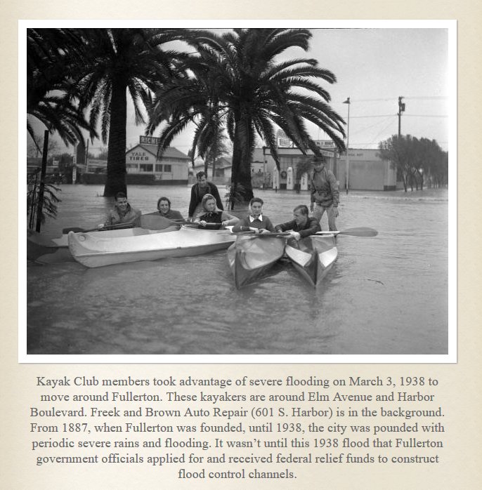 That was Fullerton Dam Spillway during a normal rain. The Brea Dam Spillway in a Normal Rain is similar in that rain on the slip of the spillway joins the normal flow out of the dam. The rain collected by the slip empties out onto the dirt of the Fullerton Driving Range, then flows under the driving range in a very large (8′ by 8′) underground channel along Harbor and under Brea Blvd where it opens up in front of Hillcrest Park. (This is Brea Creek.) In very light rains it soaks into the dirt of the driving range and never makes it to Hillcrest Park. The flow under the driving range is along Harbor and then under Brea Blvd is the only place Brea Creek cannot be seen. When it emerges in front of Hillcrest Park, it is in a very scenic dirt ravine. It is for the sake of looks that it is dirt lined. The rest of its journey through Fullerton is concrete lined but open. (Where it is most visible is alongside Chapman which becomes Malvern further west.) It is interesting to note that the Brea Creek channel through Fullerton was built two or three years before the dam went in. The great flood the students were enjoying here was 1938, the same year as posted in brass plaques on the side of the channel. It is most likely that the channel construction took place shortly after the flood.

The Velocity of Water Out of a Dam
The penstock that controls the flow operates somewhat counter intuitively. There’s hardly any pressure when the water level against the face of the dam is only 5 feet or so. In that case the penstocks have to be fully open if the operator wants to fill the downstream channel. But in a huge storm where the water level against the dam is at 30 or 40 feet, the pressure is so great that the velocity out of the back of the dam is like that of a fire hose. In that case the gate opening is made much smaller to maintain the same cubic feet per second downstream. But that doesn’t reduce the velocity. The downstream channel in many places is just dirt. The velocity and turbulence has to be reduced before that point is reached. The reduction is done in that 500 feet of concrete channel under the dam. (That’s why the penstocks are way out in front of the dam instead of in the middle.) It’s not that the energy is dissipated in this case. Over that distance turbulence merely allows the water to build up in depth so it fills the channel to its full height of 5 feet. By the time it leaves the concrete lined part of the channel, it won’t be eroding the dirt banks.
From the Dams to the Sea
Both Fullerton Creek (out of Fullerton Dam) and Brea Creek (our of Brea Dam) turn right about in the middle of the city of Fullerton and then they go exactly west. Where they join Coyote Creek in Buena Park is concrete lined and nothing to look at. Coyote Creek itself is a familiar site driving on Beach Blvd near Rosecrans. The Coyote Creek joins the San Gabriel River and then to the sea.
 The Mystery of the Satellite Dike
The satellite dike is right next to where you can park to get at the middle of the Fullerton Trail that links San Juan Park to The Brea Dam Recreation Area. The mystery is why in the heck did they put that dam, (dike) there when the water would just pour out through the cut made for the union pacific. You can tell, just by looking, all the water would drain out through that cut made 20 years earlier. The mystery is resolved when one learns from the dam operators that it blocks water on the other side; backwards from all other dams in the county! Here’s the story:
____If the flooding did fill both the recreation area and the golf course, there’s an unnatural opening that would let the water out into the city. It is the Union Pacific rail line which cuts through a hill under Harbor. This cut is discussed in more detail in the webpage–> San Juan Park Trail. The dam-like structure in the picture to the left is a dike that prevents water from escaping out though that cut created in the 1920s.

A dike holds back water. That’s different than a dam. A dam has as its purpose a controlled flow under the dam. Or it maintains the exact level of a lake on the upstream side. A dike merely blocks water. There’s nothing to control and thus cheap as dirt. As you can see in the photos, there’s two round openings in our dike that makes this dike very interesting. On the other side are flaps making them one-way valves. When the water on that side is touching those flaps, they shut and the dike is protecting the area upstream. It prevents water from escaping out the Union Pacific cut. But early on in the storm water will be flowing the other way; the normal downstream direction where it goes through those openings. Every time there’s rain, water will be flowing in such a way the flaps open up. The dike isn’t doing its job until the water downstream has back up to the dike. If you have ever been in a flood you know by experience of the surprising way water flows. It flows uphill. Normally all the creeks, even the flooded streets take water downstream. But when the water fills the lower parts of the flood basin, this wide body of water slowly moves up stream. The unexpected sight adds to the panic that is the experience of a flood. That’s when the flaps on the dike closes and traps the water from going any further upstream there.
 Dam Tender
The title of the person in charge of a dam has changed through the years, from tender, to care-taker and now operator. The hostel (picture to the left) is located on the property of Brea Dam Park. It was where some of the crew lived who built the dam in 1942. Later the dam tender and his family moved in there. It was eventually abandoned because they didn’t like to be assigned where to live.
___Each dam has a principle operator, with three assistants who are in turn responsible for the other dams in the area. They live with their families in North Orange County, like the rest of us. The four dams this team is responsible for are: Fullerton Dam, Brea Dam, Carbon Canyon Dam and Prado Dam. You can tell they are at their posts regularly because among their jobs is weed abatement and litter pick up on the sides of the dam and the place is always spotless. Graffiti is gone in less than a day. It is interesting job; they weed and paint but they also read sensors, and operate the machinery that protects hundreds of thousands of lives. Hidden heroes.