The main walk associated with the Muckenthaler Cultural Center is unusual in that it is a loop on the end of an out-and-back. The “Muck” as a starting point is easy to drive to with plenty of parking. It is also the best ending place; as a goal to a walk. What makes the “Muck Walk” really special is the Muckenthaler itself. It has the most “going-on” to participate in when you get back. The Muck is both the best starting point and the best ending point of all the walks in Fullerton.
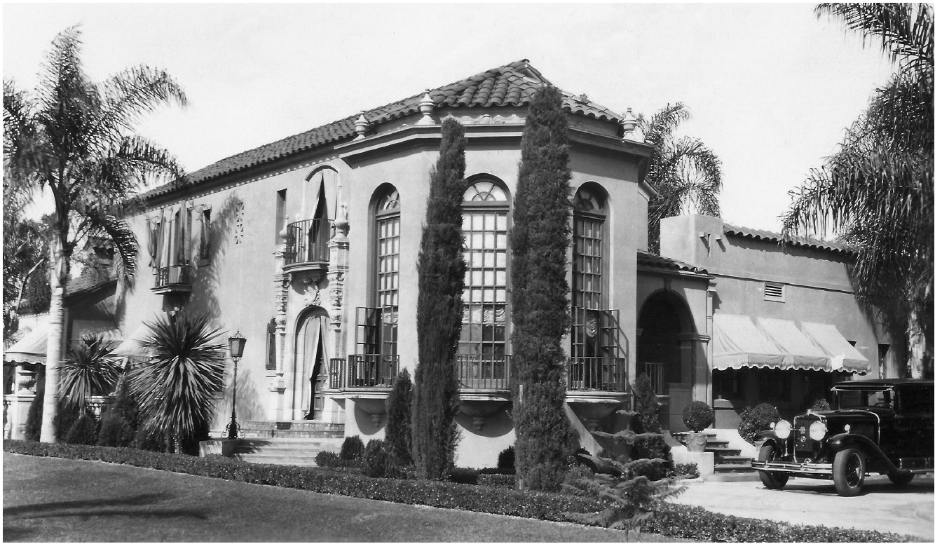
 Parking at the Muck is virtually infinite. This place after all, is host to the annual Car Show where hundreds of vehicles are on display “on the lawn”. For those seven people left in Orange County who don’t know where the Muckenthaler is, it’s on Malvern a block west of Euclid. (Those same seven probably need to know that Malvern is the same as Chapman.) The asphalt parking lot is around the back. What you won’t be using is the red concrete circular driveway around palm trees. Can you–> picture 1924 Cadillac in the circular driveway in front of their house?
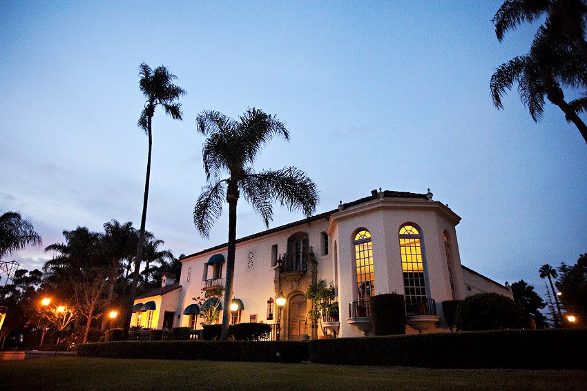
 Their car is gone, and the garage has been converted to an art classroom, one of two art classrooms. The Muck has an art gallery that changes four times a year. It is THE art and music cultural center for the city. It produces more than 60 performances a year, gallery exhibits, festivals and special events. There’s more than 3,500 hours of arts education classes there on the grounds of the Muck. You can plan on every Thursday throughout the year that some event is going on in the evening. During the day, plan your walk to arrive back between noon and 4:00 to see the art gallery and talk to the staff. That’s every day except Mondays.
Click this –>to be on the mailing list for events
Click this –>for the 2018 Season of Events
Click this –>Concours d’ Elegance
A Half Mile Loop of History
The loop around the grounds, takes no words to describe. But describing the walk does offer an excuse to experience the history of the landscape. A good place to start this easy walk, is the palm trees in the center of the circular driveway. Proceed down the stairs toward the gazebo. To the left of the gazebo is a recent architectural finding of what might have been a fountain or water feature of some sort. Walk past the gazebo toward the corner of the property where the Muckenthaler sign is. All of that corner was once a pond. There is something of a mystery about that pond. To look at it now, there’s no way to keep the water in.
____In 1924 Malvern was further from the lawn being only one lane each way. And the level of the land where Buena Vista is now, was the same as the wall along Malvern. Daniel Lindsey related this story (in facebook group: Growing Up In Fullerton) about the pond. (It was his father that removed the bamboo that was near the pond.) Buena Vista was a dirt alley and did not reach Malvern because there was a hill there. That hill was the south bank of the pond. When Buena Vista was paved and turned into a street it was made to meet Malvern, by removing tons of dirt.
 Walter and Adella were not comfortable having a pond there and did not object to it being filled in with the removed dirt. It also allowed a better view of the house. The source of water for the pond may be the recently found plumbing next to the gazebo. It might have been quite a water bill. It certainly wasn’t just rain water that kept that pond at a fun depth.
____South of Malvern and south of the barranca even… from Euclid to Basque, eighty acres, was Muckenthaler’s fruit orchard. There was no bridge over the barranca because it was just a small U-channel. The much larger walled channel went in, in 1940. (They could walk to Euclid –called Nicolas then– and cross there. The Stater Bros shopping center is still in the family.) Eighty acres wasn’t a lot in those days. The orchard could maintain their lifestyle (Cadillac, grounds keeper, etc.) but the mansion was from Adella’s side of the family. (She was a Kraemer.)

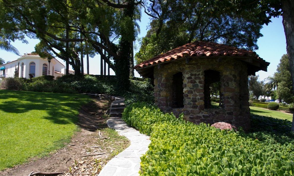
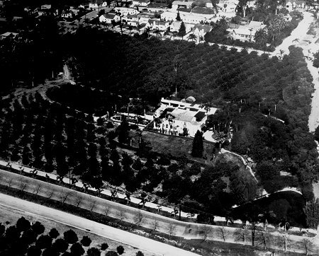
Walking east where the south pond embankment used to be you will be where the wall starts (moved there when Malvern was widened) You will have to walk steeply up the grass to walk along the top of the wall. (You may want to walk higher up where it isn’t so steeply tilted.) When you come to the west end of the property, go north where you will of course appreciate the huge trees on the west side. It’s not clear how many go back to the twenties but an aerial photo of the place (see photo gallery below) shows large very mature trees in exactly the same place. The walk along the west and north side is also the edge of the property in the 1920s. There were fruit trees where there is lawn now. When you get to the north east corner of the property, you can see the palm trees in the center of the circular drive where you started the walk. But instead wander about in back of the mansion to see all that was added to make this mansion into an art and cultural center. The rose garden is for weddings, the stage and patio for small events. Then there’s the 240 seat outdoor theatre. It has little tables at each seat so that most events can involve wine, beer, snacks and sometimes box lunches.

Out-and-Back to Hiltscher Mini-Park (1.0 mi)
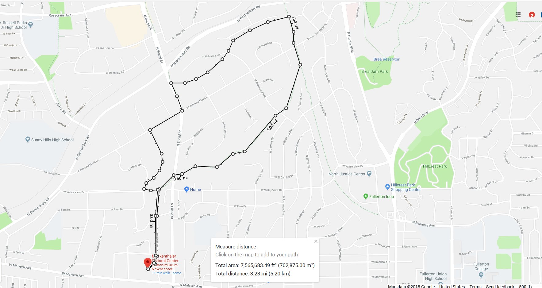
The premier walk for the Muckenthaler is 3.2 miles. But, consider this one a warm up that is only ½ mile each way. Or it can be a kid’s walk. It starts by walking down the red concrete driveway and then up the street taking the right fork. That’s Ramona Drive; a paved alley which is unlikely to share a car with you. It’s a bit of a climb and then a steep descent. At the bottom walk slightly to the left about 50 feet to a sidewalk which during a storm conducts water. At the end of that concrete walk, is the Hiltscher dirt trail. For this walk take it up hill. (The other direction on the Hiltscher is the longer walk described below.) At the top of the hill, the trail ends at a street. The late afternoon picture below is looking east, where it is a very welcoming “beginning” of a trail. From the street you will see a welcome sign and railings which define the space to be a park. It is wide up there and could easily accommodate 50 people if tables and chairs were brought there for a party or luncheon. You will of course return the way you came.

Here’s a bit more about bikes on the Hiltscher Trail. Going east, it crosses Euclid and goes another eight-tenths of a mile to meet yet another trail going north/south; the Juanita Cooke Trail. Both of these are the base leg of the “Fullerton Loop” which is famous among all serious bikers in the area. It’s exactly a half marathon in length and mostly off-road. There is a direction to bike traffic on the Fullerton loop. It is up hill here. And where they leave the trail at the top, is the only portion of the loop that is not off-road for them. It’s about a mile along West Valley View Drive which up here has very little traffic. They pick up the dirt trail again at Parks and Bastanchury. The picture above is looking east at the mini-park at the top of Hiltscher Trail.

Out-and-Back to the End of Hiltscher Trail (2.0 mi and 2.6 mi)
Begin this walk down the red concrete driveway and then up the street taking the right fork. This is an alley which is a bit of a climb. When you get down on the other side, walk to the left about 50 feet to a sidewalk/drainage ditch. At the end of that very concrete walkway is the Hiltscher trail. Turn right and note what could be a gorgeous small park. In a storm it’s a shallow lake which may be why this hasn’t been turned into a park. But wait until you see the potential for a park on the other side of Euclid. This signal, by the way, is the only one in Fullerton that serves just a trail crossing. The Hiltscher Trail can be considered a park because it is so wide. It is so wide, in fact, there’s actually two trails. Do consider going up one and down the other when you come to Richman Knoll. If Richman Knoll turn-around is as far as you go, the distance out-and-back is exactly two miles.
Richman Knoll is not the end of Hiltscher though. If you want to add a bit more to your walk, the next destination is the Garden of Weeden. It’s at the end of the Hiltscher Trail. You will have to climb about 30 feet in the last 100 feet or so. There it joins the Juanita Cooke where you will see The Garden of Weeden. A home owner has provided a water fountain and even a doggie bowl. The log seat was carved by Rubin, one of Fullerton’s grounds crew. This is a good turn around point (making it 2.75 miles total) but as you can see the trails of Fullerton seem to go on forever. To the right (south) is the court house on Harbor. And to the left it goes all the way to Imperial. Click here to go to the–> Juanita Cooke Trail webpage. That page is heavy on the history of that trail. From 1918 to 1938 it was the Pacific Electric. Yes the Red Car went through Fullerton.

The Loop on the End of an Out-and-Back (3.2 mi)
This is the big one. Follow the instructions above for going to the 2.0 and 2.6 mi Out-and-Backs. But in this walk you will be on the Juanita Cooke Trail for a while (north) before returning through a very narrow path called Horse Alley. (The opening to this trail pictured on this link is just 300 feet before the Bastanchury crossing.) The word alley is appropriate because you will be walking between people’s backyards. Horse Alley is a quiet, very hidden trail and somewhat disconcerting in that you may feel like you are constantly on someone’s backyard. You will see goats and horses kept as pets; vegetable gardens and swimming pools. There’s a bit of trickiness in this trail when you come to a street. The picture to the right shows what to do. From there on to Euclid there’s no confusion so enjoy the adventure.

When you come to Euclid, the trail will be joining the sidewalk going north. You will need to do a 180 to walk on the sidewalk going south (uphill). Notice that the sidewalk is not what you would expect on a major street. That’s because you will be on the Bud Turner Equestrian Trail. Horses, like most walkers, prefer dirt to walk on.
It’s about half a mile on Euclid to the Hiltscher Trail signal light. But that’s too noisy. Instead cross right away at Valencia Mesa and keep walking on Valencia Mesa to the first left. That’s Crestview Drive. On the map above, note that Crestview Dr meets another street which you will walk on a little further until you see the mini-park that marks the terminus of the Hiltscher Trail. Down hill there and to the right you will recognize your way back to the Muck.
Click the picture to see it full screen.