The Union Pacific trail starts at Bastanchury Park and goes north for many miles. What is describe below are several trips out and back along this trail. You needn’t read any further if you just walk until you feel you have gone half your limit then walk back. But to insert some history and trail philosophy, the discussion below is grouped so you can skip through to only read what you might think would be of interest.
Within the Park
The starting point for the trail is Bastanchury park. And parking there is on Bastanchury near Malvern.
The trails within Bastanchury Park are concrete sidewalks and perfectly smooth decomposed granite. There is of course picnic tables, restrooms and ball diamonds. The long trail that is associated with this park is actually on private property; Union Pacific. The line is abandoned, but rail and 20 ft on either side still belongs to Union Pacific. It is because of that, this is an unofficial trail and that is why there is no access to the trail from the park. This line used to service the Hunts tomato sauce factory; its only customer. Vegetable oil came from Los Angeles on this line as recently as the 1980s.
___This trail and adjacent railroad track follows Bastanchury Road for a while then separates going north for a mile or two. Then past Lambert where it curves left around Home Depot on Harbor in La Habra. It goes west after that into Los Angeles. If Rails to Trail comes to Fullerton, the trail would stop about Imperial. After that, it is well used by Union Pacific. If it is converted to a trail the Parks Department would certainly make it more convenient to get to the trail from Bastanchury Park. So, as of 2019, you just use Bastanchury Park to park your car then leave the park to get at the trail as described below.

The trail north along side the Union Pacific begins at Malvern, but the most convenient way to get on that trail from Bastanchury Park is to walk north past the north ball diamond, (behind the third base line) and then climb the embankment to Hughes Drive. Cross Hughes Drive then take the trail below the tracks some 50 feet away. Click here to see how two trails divide.
Potential Expansion of Bastanchury Park
There is an alternate way, from where you parked, to the trail. It makes your journey longer but it can be a step into the future. Walk out the main gate of the park and walk south on the decomposed granite sidewalk which slowly curves west to the railroad tracks. Step over the tracks to a similar decomposed granite sidewalk going north-west up a hill. This short trail (on the west side of the tracks) is a gift from the housing developer to the city. And they maintain it still. It’s short and ends at Hughes Drive (quarter of a mile) where it then drops back down to the track level. Hughes Drive is the north end of the park and the first way mentioned above to go from the park to the trail. This leaving of the main gate of the park, south and then curving around the back of the park, makes your journey a half mile longer, but you also get to see the potential of Bastanchury Park if the Trails to Rails program takes hold. The right of way there would add a hundred feet or more to the park for the full length of the park. On the other side of the embankment made for the railroad (unseen) is a 4 acre private park which Hydraflow Corp allows high schools to play La Cross on for certain scheduled events. Its fun to think that private park could be linked to Bastanchury Park if the double set of tracks are removed and that space becomes more park.
The Union Pacific Trail
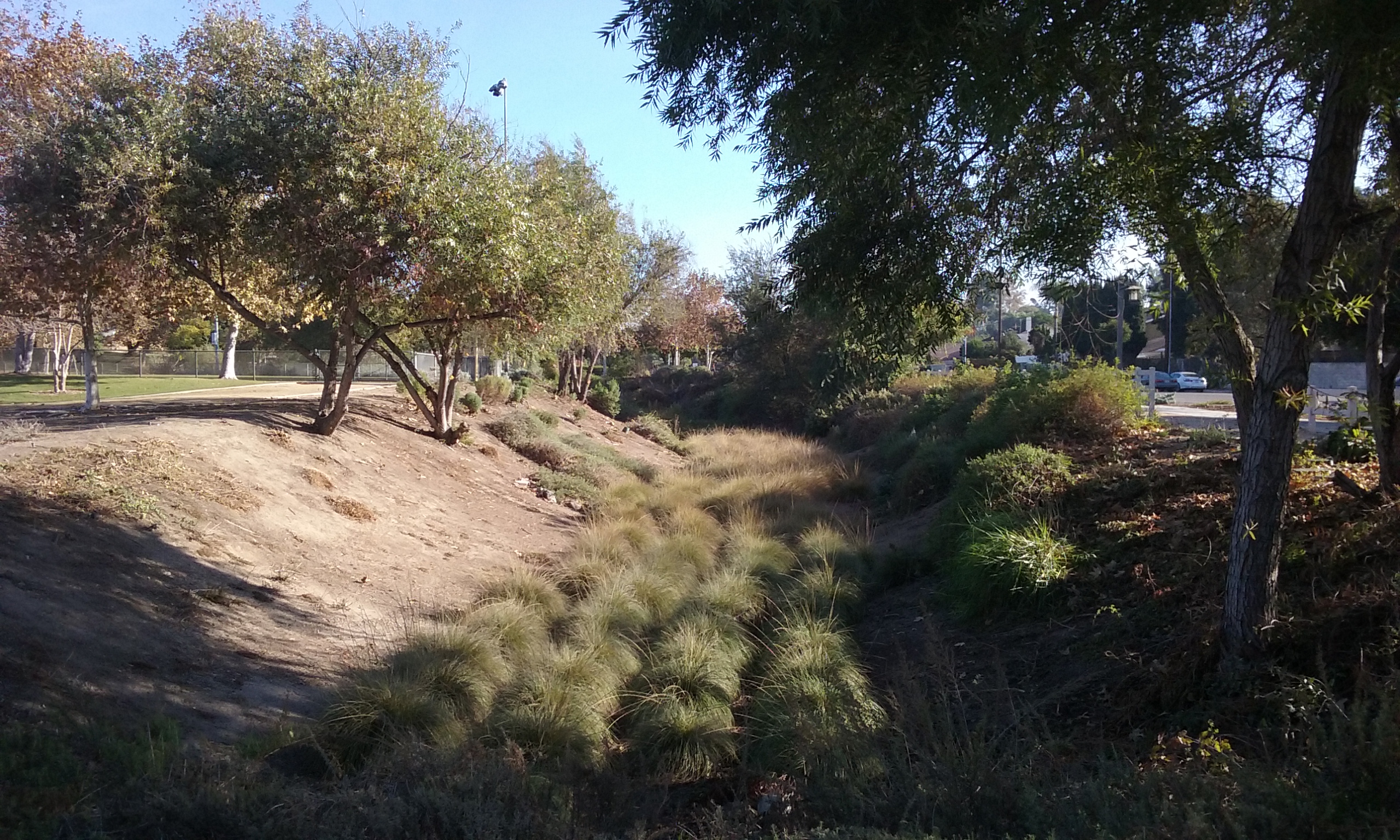
Beyond the park, the trail is only a few dozen feet from the tracks but it is lower down and consumed in trees. It doesn’t come back next to the tracks for about half a mile, a mile which is a wonderful tree lined experience. What you will be walking through is a tree nursery. After the pastoral experience of so much greenery there’s a walk that unfortunately follows pretty close to Bastanchury Blvd. (An interesting note about Bastanchury Blvd is that it used to be a Santa Fe spur that went almost to Harbor to a loading dock for Bastanchury orchard.) If you continue following the tracks, in about a mile it passes underneath the Juanita Cooke Trail and for the adventuresome past the golf course and clear to Imperial and beyond.

Short Walk (out and back 1.2 mi)
The most worthwhile part of the walk out of Bastanchury Park is immediately out of the park across Hughes Drive for the half mile. It is the shadiest in all of Fullerton. As described above when crossing Hughes Way, you will choose the lower trail. Bikes prefer the harder ground next to the tracks, but by far the more pleasant walking journey is the lower trail through Senna Tree Company’s tree nursery. It is left over from the housing developer that planted trees in the housing track which used to be Raytheon’s upper campus. To make it a Short Walk, turn around at Parks Road.
____There is confusion (for the users anyway) as to who is in charge of trail maintenance and in particular clean up of homeless nests. The beauty, the shade and the seclusion of this walk is not lost on the homeless. One can’t help but admire their choice of where to stay. Because of the homeless nests, the walks associated with the Union Pacific Trail near Bastanchury Park, might not be good for picking up trash for exercise. There’s just too much. It might even be too much too often to call in superior forces with the MyFullerton App. But this might be a good place to introduce you to the MyFullerton App. It is described about half way down if you click–> here.
Like the trail along the tracks, officially, we really shouldn’t be walking through the privately owned nursery; Senna Tree Nursery. There’s one employee for the whole farm. He waters all the trees; each tree getting water two or three times a week. His name is Juan. Juan is very nice and loves to talk about his trees.) Private property where no one lives is rarely fenced, and so there’s nothing they can do to keep people out. Click here for more on–> trail philosophy.
 Slightly Longer Journey from Bastanchury Park (out-n-back 3.5 mi)
The short walk leaving Bastanchury Park mentioned above, is by far the most pleasant. But for more exercise you can continue walking past Parks Road to Euclid. That’s 3.5 miles out and back. Just passed the tree nursery between you and Bastanchury is the agricultural teaching farm of Sunny Hills High School. And beyond Parks Road is more of the Senna Tree Company Nursery. This part of their nursery is nowhere near as pleasant a walk. If instead of turning around at Euclid, if you cross Euclid and continue past the animal hospital to the horse stables, that is something of a treat to watch; horses. 24 stalls in a stable owned by a lady with the unusual name; Versa. There’s always something going on to watch. Most interesting is the horses and their owners take turns exercising in the arena.
Lunch on Laguna Road (out and back 5.5 mi)
Beyond the stables (Euclid and Bastanchury) is a rather noisy part of the trail because it is so close to Bastanchury. After a half mile of this closeness to Bastanchury, the trail follows the tracks to the left separating from Bastanchury which curves to the right. The trail to the left is surprisingly secluded. It comes back into civilization at Laguna Road. Out and back to that point is 5.5 miles.
___If your goal is lunch continue up Laguna Road about 2 blocks. There, just beyond the top of the highest point is access to a parking lot for businesses that face Harbor. Enter there and look for The Hungry Bear Restaurant. Next to it is T.C.s Yummies, a sandwich shop that caters to the lunch crowd (It closes at 2:00) Continuing on Laguna Road, it crosses Bastanchury where there’s a few other places to eat. 
There a bit of history on Laguna Road on the south side of Bastanchury. It has no archeological remains but terribly important to the history of Fullerton; the loading docks for what was at the time, the state’s largest fruit orchard, the Bastanchury Ranch. Laguna Road (on the south side of Bastanchury) becomes parallel with Harbor for about a hundred yards. It is right there that Pacific Electric had a loading dock. (It was a spur from the mainline that is now Juanita Cooke Trial starting about where it meets the Hiltscher Trail.) Union Pacific and Santa Fe also had sidings near there with their own loading docks. In the picture to the left, note the overhead wires for the Pacific Electric “Juice Pack.” (see Juanita Cooke webpage for more about the Electric Trains Through Fullerton.)
Loop (6 mi)
Starting at Bastanchury Park following the trail alongside the tracks as it curves to run north you will come to a street. It is Laguna Road. From Laguna Road you can take a different trail back to make a kind of loop that is only a bit farther than the out and back walk from Laguna Road. Instead of turning around and walking back, walk up the street a short ways to Morelia. Walk south and cross Bastanchury at the signal light. Right there is the rather expensive dirt ramp to the Juanita Cooke. About a hundred feet in, go through the opening in the fence on the right; that’s Horse Alley (<–click there for more detail). Take Horse Alley clear down to Euclid. You will see Bastanchury to your right; cross Bastanchury and you will recognize the train tracks back to Bastanchury Park.
Tracks South of Malvern
The elephant in the room is the Union Pacific. It is there at every foot fall once out of Bastanchury Park. It’s pretty definitely abandoned because street crossing signals have been turned around from Malvern to where the line passes Lambert. This is potentially another Juanita Cooke Trail; a longer version even. About where Home Depot is (On Harbor in La Habra) the abandoned line joins a one customer active rail line which dead ends going east where “The Tracks Trail” starts in Brea. But the other way, the active line goes all the way into L.A.
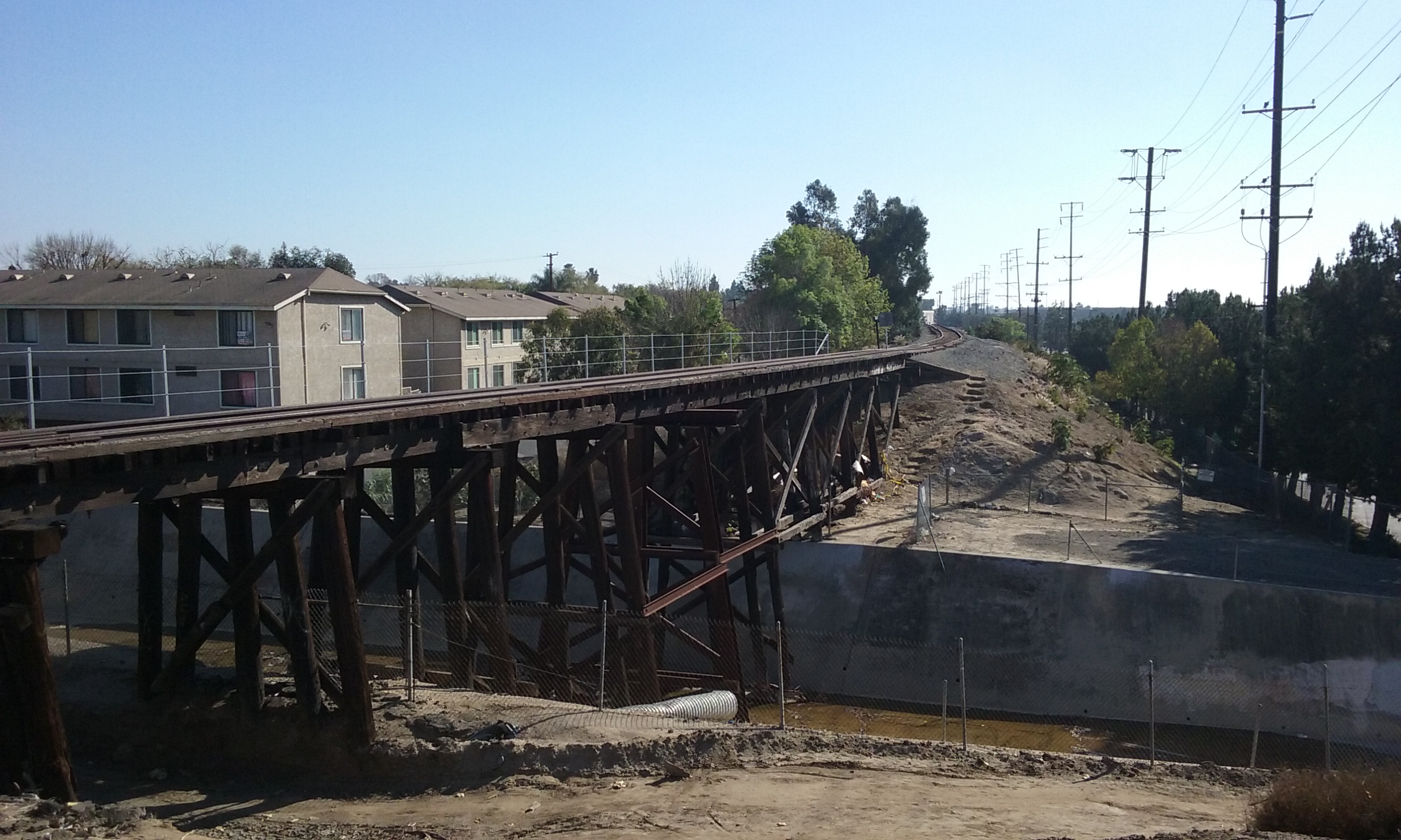
____But at this Bastanchury Park end, where does the Union Pacific go? How far is it abandoned south of Malvern? At one time it joined the mainline to Fullerton Station. The Spaghetti Factory was the Union Pacific Station when it was physically located on the south side of the main line. The picture to the right, above shows a wooden trestle bridge over Brea Creek on the way to the mainline and of course past the Hunt Wesson factory. There’s fences everywhere but the walk way along this bridge is not blocked. ?!? And its fairly new. (There must be an interesting story about that.) If one follows it across the bridge the path gets narrower and narrower until you have to climb down the side. As you can see in the above photo the track is on a large berm that fills a large right-of-way (for a half a mile). Alas this property is unavailable for any commercial use, being filled with so much dirt. The track merges with the mainline quite near the bridge over Commonwealth. (The one near Pooch Park, and the old west branch library.)

If it is abandoned to the point of turning the crossing signals around, then why can’t they take their rails and rocks and go home? We should be grateful though for the Union Pacific preserving this line for us. And someday they will be tired of paying the taxes on that property and want to give it to the city. (Like what Pacific Electric did to turn the rail into a trail; the Juanita Cooke Trail in 1962. But that was before the EPA.) The problem one of our councilmen pointed out is that Union Pacific is the deep pockets in case the EPA gets anal retentive. It is a problem for most abandoned properties where even a single drop of weed poison is detected. Million dollar studies would be required of Union Pacific to inspect the ground. And on the likely occurrence that poison was found there’s the cost of digging up all that rock and the dirt underneath it and sending it to Nevada. All that can be avoided by just doing nothing. It is cheaper for the Union Pacific to keep paying taxes on the property.
Click on a picture to see it full screen.


